
Links to information on
If you believe you see or smell a wildfire starting, call 911.
It can take time for these sites to post information on new fires.
Other websites that can help you understand wildfire conditions like wind direction and speed, and to some degree the air support working on suppression, are (note, some disclaim accuracy):
- National Wildfire Coordinating Group's active fires map (Wait for data to load. Satellite heat-detection-dot colors mean: red = within last 12 hours, orange = within 12 to 24 hours, yellow = 24 to 48 hours. Dots/detections older than 48 hours are removed from the map. Some inaccuracies, but very helpful information.)
- CAL FIRE's Current Fire Information web page (Active fires have a red icon, old fires gray.)
- InciWeb California Fire Incidents web page (Focus is on fires on Federal land.)
Other websites that can help you understand wildfire conditions like wind direction and speed, and to some degree the air support working on suppression, are (note, some disclaim accuracy):
- ALERT California shows you real time views from wildfire cameras. To find cameras for your area of interest, zoom in on the map to include only the icons for cameras you are interested in seeing views from, then to see views from a specific camera click on its icon on the map then click on the hyperlink in the label that pops up, or, click on the image from the camera on the right. To return to see all cameras you are interested in click on "Camera Management." To learn how to use all features on the ALERT California website, watch its Tutorial Video.
- Zoom Earth (Shows wildfires and wind speed and direction, and disclaims accuracy. Move your cursor to see estimated wind direction and speed at that spot.)
- Flightradar24 (Shows aircraft, including some firefighting fixed wing and helicopters, but not all. Click on aircraft icons to see details.)
|
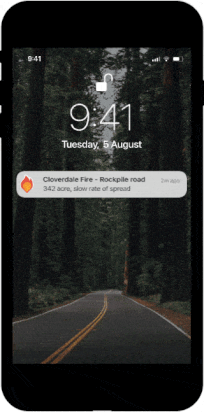
Click here to get the free Watch Duty App for your Apple or Android smart phone, to be alerted when there is a wildfire within the area you select, with a fire-start location pinpointed on a map, and with updates as the emergency unfolds. Below is a short video explaining how Watch Duty works.
|
|