History of wildfire in Monterey County
|
MONTEREY COUNTY HAS A LONG HISTORY OF WILDFIRES The topography and semi-arid climate combined with extreme heat and drought all increase the area's susceptibility to wildfire. This region is prone to prolonged droughts, the most notable being; 1987 to 1992, 2007 to 2009, 2012 to 2016, and 2021 to the present day (as of this writing, December, 2022).
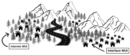
Due to its physical conditions, much of Monterey County has been determined by CAL FIRE to fall within High to Very-High fire hazard severity zones. In 2009, stakeholders in the community came together to complete the Monterey County Community Wildfire Protection Plan (MCCWPP), an advisory document that details key fire risks within the region and recommends measures to make the county safer in event of wildfires. (More on MCCWPP). The CWPP has been updated about every four years since. As detailed in the MCCWPP, "In addition to weather and topography, vegetation (or fuel) plays a major role in affecting fire behavior and shaping fire hazard potential. Vegetation distribution throughout the county varies by location and topography, with dramatic differences observed between the coastal, valley, and inland regions" (MCCWPP). This particularly affects homeowners who live within the Wildland-Urban Interface (WUI). Generally, the WUI is where human structures and forests or wildlands meet. When in proximity to dense accumulations of wildfire fuels in wildlands, communities located within the WUI are at higher risk of experiencing wildfires. The WUI is the main focus of the Firewise USA® Communities program, encouraging making homes more fire resistant and reducing wildfire fuels to safe levels. Exactly where is the WUI? According to this USDA report, "There are many ways to answer this question..., depending in part on how specifically one defines WUI."
There are a number of maps you can look at to learn if where you live is in the WUI. The maps are similar, but due to using different definitions of WUI are not the same. For example: The WUI map for purposes of the federal Healthy Forests Restoration Act is in the Monterey County Community Wildfire Protection Plan (Appendix B, Map B7, page 129 in pdf software). One of CAL FIRE's WUI maps, from 2015, is here. Monerey County's WUI map is here WUI Area | Monterey County. Resources: Glossary of Wildland Fire Terminology What is the WUI? (fema.gov) History of Wildfire | MCOES |


